Trinity River Watershed, Dallas, Texas
Challenge
Dallas has experienced chronic flooding for more than a century. The Trinity River, which flows through the heart of the city, has long contributed to these flooding challenges and was historically managed using levees and channelization. Following heavy rains during the first five months of 1990, the Trinity River’s waters spilled out over its banks, leaving approximately 6,000 residents across 68 counties applying for federal disaster assistance.
Project Details
- Location: Dallas, Texas
- Population: 1,281,047 (2014)
- Cost: $91.7 million (granted to the Corps from federal funds), $6.085 million (city)
- Strategies: Floodplain Restoration, Flood Detention Areas
- Benefits: Flood protection, Wildlife habitat, Migratory bird flyway, Recreation, Wildlife viewing, Wildlife biodiversity, Economic security
History
Flooding from the Trinity has been a challenge since the early 1800s, when the city began to take shape. As a result, in 1919, the Kessler plan to construct 30-foot-high levees along stretches of the river was approved. In 1928, an extension of the Kessler plan was built, which aimed to protect nearly 10,500 acres from flooding with viaducts, minor crossings and levees.
In the 1950s the Trinity River was further channelized, and levees were modified through the Major Corps Dallas Floodway reconstruction project. However, by the next decade, two main factors contributed to the reduced effectiveness of the Floodway. First was significant development in the Trinity River watershed, specifically in the Dallas-Fort Worth area, which led to an increase in runoff and more water flow volume. Downstream, thousands of acres were converted from farmland to woodlands, which decreased water discharge from the floodway.
These changes came to a head in 1990 when early season rains across the region pushed the Trinity River to near historic flood levels. Extensive damage occurred across the entire watershed, forcing thousands of people out of their homes and causing millions of dollars in damages.

Solution
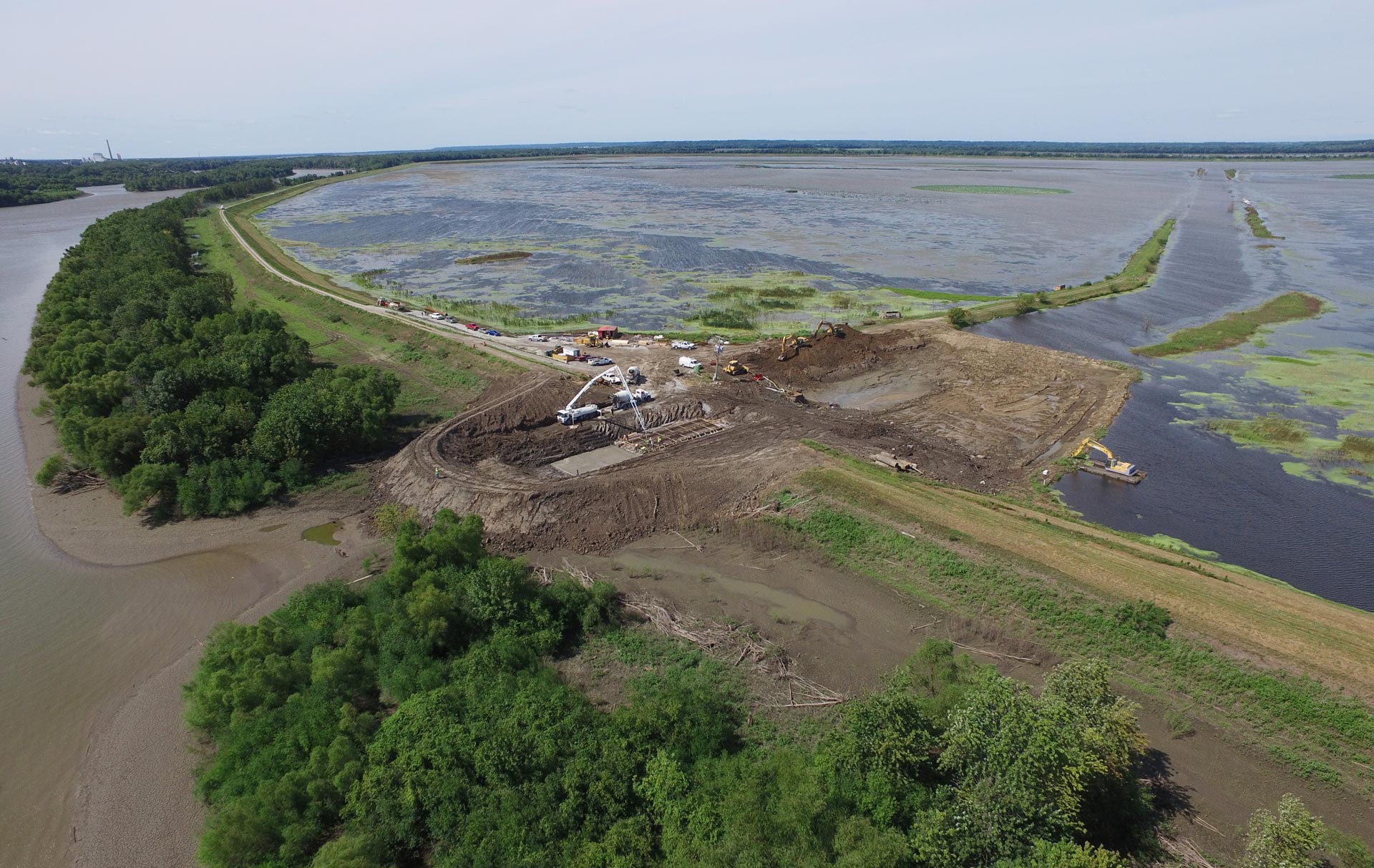
Following the devastating floods of 1990, the U.S. Army Corps of Engineers decided to take a combined approach to floodplain mitigation. This plan, called The Chain of Wetlands, is part of a larger Dallas Floodway Extension (DFE) project to improve infrastructure and prevent future flooding. The Chain of Wetlands Project can be separated into two sections: The Upper Chain and The Lower Chain. The Lower Chain is complete, while the Upper Chain Project is ongoing.
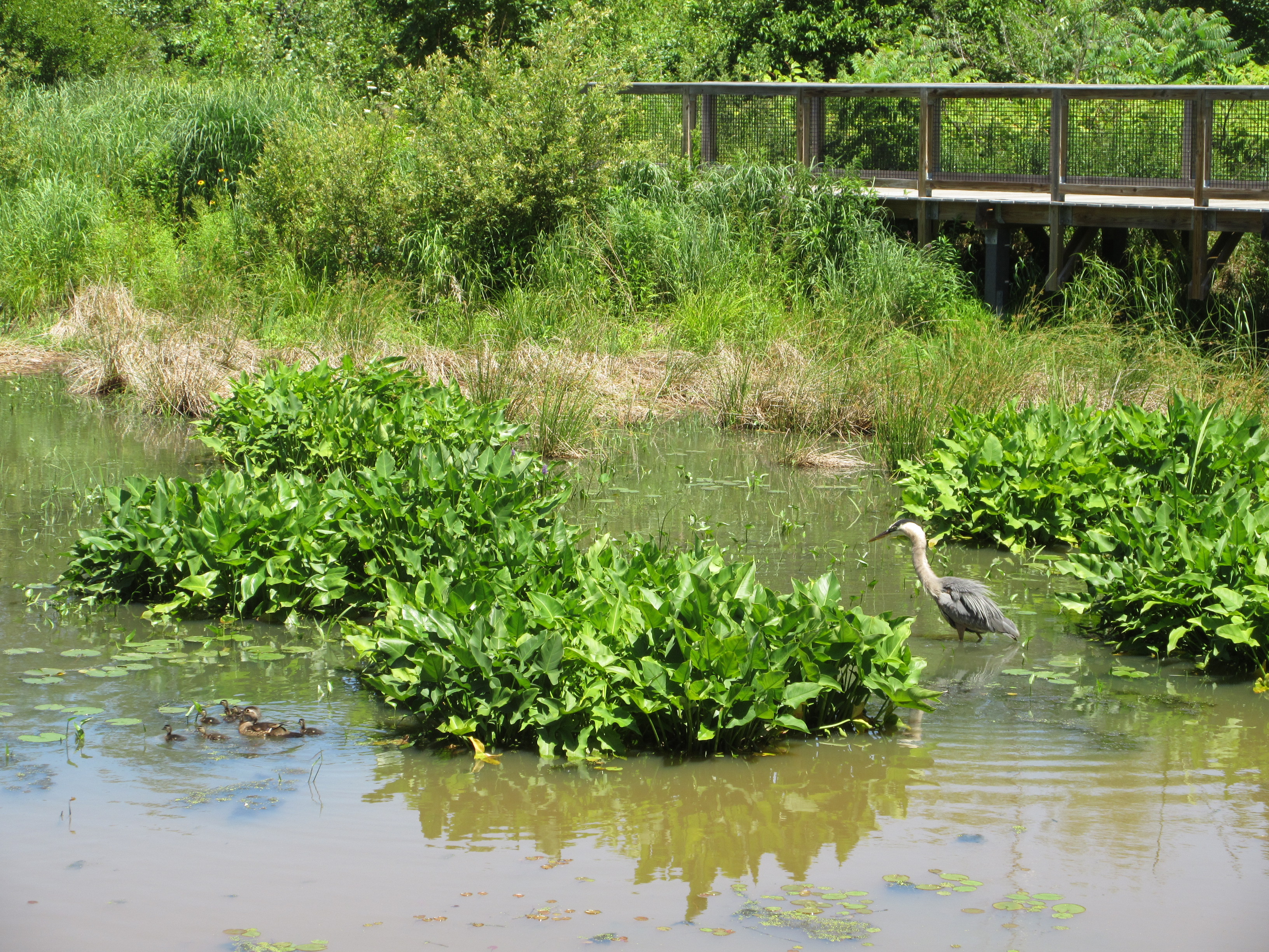
Once complete, the Upper and Lower chains, with seven cells combined, will total 3.7 miles in length and average nearly 600 feet in width. These cells will serve as permanent wetland habitat for the many species in the region. They will include about 271 acres of improved habitat, with 45 acres of open water, 123 acres of emergent wetlands and 102 acres of grasslands. Typically, wetlands in northern Texas dry up in the summer; but this design pumps water from a nearby water treatment plant to maintain its wetland status year-round. The various underwater shelf depths in the Lower Chains have initiated a diverse group of water plant species to grow in the ponds. Wetland managers monitor these sites for sedimentation, water quality, invasive species, and other factors that could affect the health of the ecosystem.
There are also designated water detention areas along the Trinity River that serve as parks and recreational fields when waters are below flood stage. When the Trinity’s water rises, the lands will be converted into a reservoir filled with floodwater. The floodwater detention areas and the wetlands work in conjunction with the Lamar levee, built upstream. This levee protects businesses and neighborhoods while the wetlands provide additional flooding protection.
Funding
At its completion, the Dallas Floodway Extension plan will total around $1.7 billion. Specifically, the Chain of Wetlands and levees portion of the project will cost $107,119,000. The Army Corps’ Fort Worth District is the lead in the project and created the final design for the Chain of Wetlands. The City of Dallas and the federal government participated in the cost-share, with the federal government contributing most of the funding.
Dallas received funding from a variety of agencies, including: the Trinity River Corridor Project Fund; Street and Transportation Improvements Fund; the Stormwater Drainage Management Capital Construction Fund; and the Trinity Trust Foundation (Dallas Floodway Extension Fund).
Benefits
The Chain of Wetlands project is projected to reduce the Trinity River’s floodwater level by 4 feet. The entire DFE will provide 800-year flood event protection – saving Dallas residents thousands of dollars. Other economic benefits are increased development opportunities and tourist attractions.
The “green” portion of this project provides conveyance for floodwaters and habitats for a diversity of wildlife. People will have access to fishing, cycling, and walking on trails through the new recreational areas. Wildlife also benefit from these newly-formed wetlands, which provide a stopover for the Central Flyway’s migrating birds.
In January 2012, a small flooding event occurred. Water flowed over the banks of the lower wetlands but receded by the next day. Although a small amount of flooding transpired, the wetlands are already functioning and reducing the upstream floodwater levels by 1 foot during heavy rain.

In Summary
After many years of chronic floods, The Chain of Wetlands Project has significantly improved Dallas’ flood resiliency. Through an integrated flood mitigation approach, this project combines gray infrastructure with a more natural design to provide additional benefits. Not only does the Chain of Wetlands give Dallas increased flood protection, it also provides residents with social, economic, ecological and aesthetic benefits.
Excerpt
FEMA recently recognized the City of Dallas’ Upper and Lower Chain of Wetlands projects in their “Mitigation Best Practices Portfolio” for reducing flooding risks. http://www.dallascitynews.net/commander-of-u-s-army-corps-of-engineers-tours-dallas-floodway-system
Sources
Media:
Roberto Suro. Texas flood ruins homes and spirits. New York Times. December 1991.
Roy Appleton. Trinity River wetlands construction brings Dallas Floodway Extension Project closer to city’s core. Dallas News. February 2013.
Roy Appleton. Work underway on Trinity Wetlands near downtown Dallas. Dallas News. January 2015.
Dallas City Hall:
Trinity River Corridor Project: Dallas Floodway Extension. Trinity River Corridor Committee Briefing. September 2008.
Trinity River Corridor Project – Legal Resolutions. August 2015.
U.S. Army Corps of Engineers:
Dallas Chain of Wetlands Fact Sheet
Dallas Chain of Wetlands Slide Show
Dallas Floodway Extension Fact Sheet
Dallas Floodway Extension Project Overview
Dallas Upper Chain of Wetlands Fact Sheet
Report on upper chain of wetlands construction contract
Report on lower chain of wetlands construction contract for habitat protection
A Balanced Vision Plan for the Trinity River Corridor. City of Dallas. December 2003.
Federal Emergency Management Agency (FEMA):
Reduced flood risk due to chain of wetlands. Department of Homeland Security. October 2015.