Mingo Creek, Tulsa, Oklahoma
Challenge
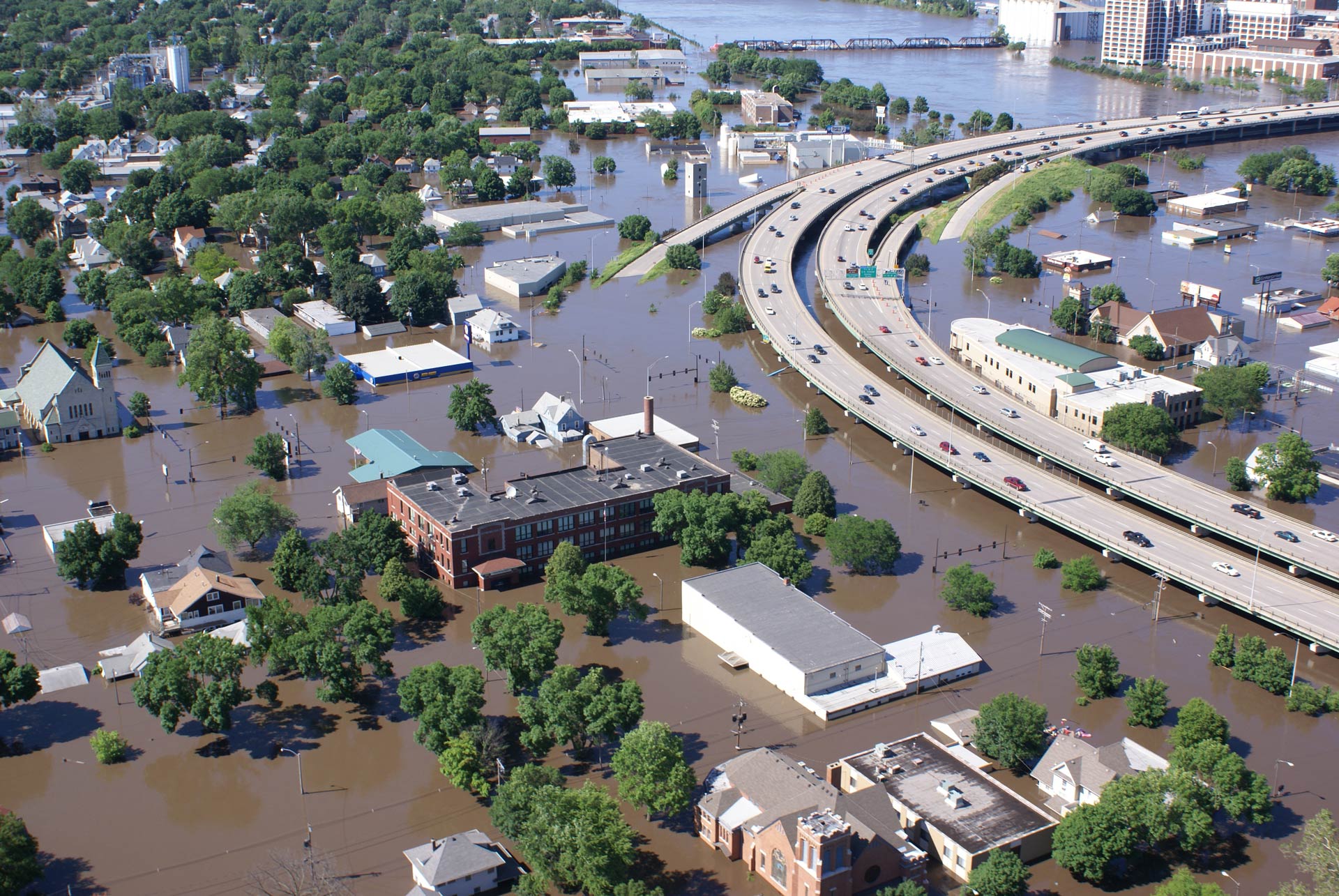
Deadly and costly flash floods were once a devastating norm in the city of Tulsa. The most destructive flood occurred on Memorial Day in 1984 when a stalled cold front poured at least 9 inches of rain over eight hours, leaving 14 people dead and injuring 288. Over 5,500 buildings were damaged or destroyed, including more than 20 schools. At the time, the cost in damages reached $180 million (over $400 M in 2013 dollars). Flooding at Mingo Creek accounted for nearly 70% of the damage, making this location a priority for the implementation of a flood control plan.
Project Details
- Location: Tulsa, Oklahoma
- Population: 1,131,458 (combined metropolitan statistical area)
- Cost: $437 Million (ongoing)
- Strategies: Moving people out of harm’s way – property buy-outs, Flood Bypasses, Floodwater Retention Areas, Waterfront Parks, Restoring Floodplains, Open Space Preservation
- Benefits: Ecological, Economical
History
In 1923, a flood that left 4,000 homeless sparked city leaders to respond with Tulsa’s first land-use plan, which advocated for upland boulevards and housing, while the Mingo Creek area would be converted to parks and recreational trails. These parks have since saved Tulsa from innumerable flood losses.
A 1943 flooding event sparked the U.S. Army Corps of Engineers to build levees surrounding the oil refineries on the Arkansas River upstream from Tulsa. Although these barriers protected the refineries, housing expansion into the floodplain created more vulnerable infrastructure. By the late 1950s, floods were impacting newly-built subdivisions and generating requests for better flood control. In response, the Army Corps built the Keystone Dam, which turned out to create a false sense of security for the community.
Every flood was met with the same protocol—emergency response and recovery, quick reconstruction, and denial of future, similar floods. However, the 1984 flood changed things. The newly-elected mayor and street commissioner vowed to respond in a way that would greatly reduce the possibility of similar devastation in the future.
Solution
In response to the 1984 flood, the City of Tulsa established the Department of Stormwater Management to improve flood control and drainage. By ordinance in 1986, the department established a stormwater utility fee to manage the program. In 1990, the new department published its plan to manage storms through 2005, which was updated in 1998 to carry it through 2014. The program aimed to prevent new problems, address and fix existing problems, and enhance the community’s safety, environment and livelihoods. One of the main regulations of the program is to welcome growth; however, growth cannot lead to either newly developed areas flooding, or contribute to flooding in other areas.
What makes the Tulsa’s comprehensive floodplain management strategy unique is how the city changed its planning paradigm to include land-use reforms and multiple-purpose solutions, in essence creating a proactive approach to flood protection. Using funds from FEMA’s Hazard Mitigation Grant Program and a 25% local match, the city implemented a successful voluntary acquisition program by purchasing flooded properties. Over 900 homes and businesses have been removed for floodplain restoration since 1984. The acquisition of these flood-prone properties allowed for the area to be converted into greenways for flood control and recreation. The construction of this network of landscaped buffers and detention basins provided Tulsa with the critical green space needed to manage flooding during major storms.
Funding
Headed by the City of Tulsa and the U.S. Army Corps of Engineers, Tulsa’s program at Mingo Creek was an ambitious 15-year, flood control capital facilities plan totaling $437 million. The city partnered with the Army Corps, recognizing that Mingo Creek’s flooding problems could not be solved in isolation; city, state and federal agencies along with the community all needed to play a role to make the project a success.
The city government established a creative and comprehensive strategy to fund the flood control plan, designed to withstand a 100-year flood event. Initial buy-in from the community was difficult. However, major public awareness and education campaigns led by the local government and strong community leaders helped illustrate the importance of stormwater and flood planning. Tulsa’s citizens eventually approved sales tax and bond issue funds of $120 million, initiated a stormwater utility fee, and the city secured over $80 million in federal funds to implement the capital flood control projects.
In 2002, successful community engagement from many non-profit programs allowed Tulsa project to benefit from FEMA’s Hazard Mitigation Grant Program. In accordance with state and federal supervision, this plan addressed many harmful or damaging scenarios, such as a dam failure upstream, floodplain management or other weather events that would increase the protection of citizens and property.
Benefits
Tulsa’s chronic flooding brought together a coalition of community, state and federal partners that successfully implemented a flood management strategy with many benefits. Since the project’s creation, local property owners and businesses have not had any major property losses due to flooding. And by allowing the city to plan around flooding hazard areas, the plan has reduced any negative economic impacts that flooding in the area could cause, which has led to social and community benefits as well. Because of its successful flood protection approach, Tulsa boasts one of the nation’s best flood insurance policies. Residents have received up to a 35 percent discount from their premiums that are adjusted to reflect their properties’ reduced flood risk.
Ecologically, the increase in green space has improved water quality, as runoff has been reduced significantly. Water detention areas that also serve as open, green areas, have enhanced wellness in the community by creating recreational opportunities at new soccer fields, parks and trails. The reconstructed wetlands benefit wildlife in the area as well.
In the early 1990s, FEMA ranked Tulsa’s floodplain management program first in the nation, and in 1992 the agency awarded the city its Outstanding Public Service Award. Twice, Tulsa has received the Association of State Floodplain Managers’ Local Award for Excellence.
Excerpt
“One of the most progressive and far-sighted cities in the nation by promoting the protection of lives and property through the application of exemplary floodplain and stormwater management principles.” –FEMA
Sources
Media:
Kelly Kurt. Tulsa Praised for Flood Control. News OK. September 2000.
Olivia Stinson. Learning from Disaster: Tulsa’s Resilient Floodplain Design. 100 Resilient Cities. June 2015.
Mingo Creek case studies:
Louisiana Resiliency Assistance Program, an office of community development, disaster recovery unit and LSU coastal sustainability studio initiative
Larry R. Curtis. Diamonds in the Rough: Utilization of Open Space in the Mingo Creek Floodplain Project. University of Oklahoma – Tulsa. 2012.
Ann Paton. A Tulsa Story: Learning to Live in Harmony with Nature,” 84-1-13. ln Jane A. Bullock, George D. Haddow, and Kim S. Haddow, eds., Globol Warming, Noturol Hozords, and Emergency Monogement. Boca Raton, FL: CRC Press. 2009.
http://resiliency.lsu.edu/2004, 2012
City of Tulsa:
Multi-Hazard Mitigation Plan: 2009 Update.
From Rooftop to River: Tulsa’s Approach to Floodplain and Stormwater Management. May 1994.
National Weather Service Forecast Office: Tulsa, OK.